-
 [Untitled]
 Battle of the Ancre. British troops preparing dinner. Note sheepskin jerkins over their uniforms. Near Beaumont-Hamel, November 1916.
-
 [Untitled]
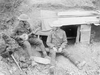
 Royal Artillery Gunners at the entrance to their dug-out. Guillemont. September 1916.
-
 [Untitled]
 Battle of Albert. British troops in a support trench awaiting their turn to advance. Note wire cutter attached to rifle. 1st July 1916.
-
 [Untitled]
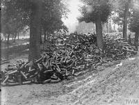
 Battle of Albert. A dump of 18 pounder shell cases used in the bomdardment of Fricourt. Extraordinary quantities of ammunition were used in successive bombardments.
-
 [Untitled]
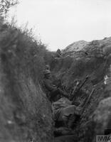
 Soldiers of 'A' Company, 11th Battalion, the Cheshire Regiment, occupy a captured German trench at Ovillers-la-Boisselle on the Somme. In this photograph one man keeps sentry duty, looking over the parados and using an improvised fire step cut into the back slope of the trench, while his comrades rest.
-
 [Untitled]
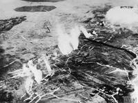
 Aerial photograph of a British gas attack in progress between Carnoy and Montauban in June 1916, shortly before the Somme offensive. Montauban, then still in German hands, is at the top left of the picture and Carnoy, behind British lines, is at the bottom right.
-
 [Untitled]
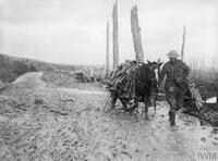
 A pack horse loaded with rubber trench boots (waiders) is led through the mud near Beaumont Hamel on the Somme battlefield, November 1916.
-
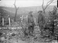
 [Untitled]
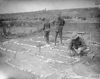
 A member of the Army Chaplains' Department (AChD) tending a soldier's grave in Carnoy Valley, July 1916.
-
 [Untitled]
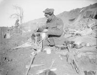
 Battle of the Ancre. A sergeant cooking his dinner. Near Beaumont-Hamel, November 1916.
-
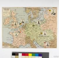 British Jigsaw Puzzle Map of Europe
 1-jigsaw, 1-solution, 1-envelope wooden jigsaw
British jigsaw puzzle map of Europe, showing the belligerents at the outbreak of war in August 1914.
-
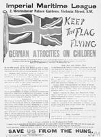 Keep the Flag Flying: German Atrocities on Children
 German Atrocities Propaganda Newspaper
-
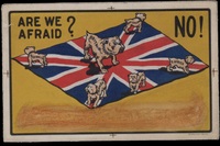 Are we afraid? No!
 Are we afraid? No!
The start of the First World War saw the publication of large amounts of supportive, patriotic ephemera designed to appeal to the market of war supporters. This postcard uses the Union Flag and the icon of the Bulldog to show Britain, Australia, Canada, India, New Zealand and South Africa standing united against a common threat. Britain, as the ‘motherland’, stands larger than the associated dominions and colonies, a statement of its role as the heart of empire but a somewhat jarring visual in a post-imperial age.
-
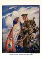 Your Motherland Will Never Forget
-
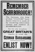 Remember Scarborough!
 British propaganda poster which saids : Remember Scarborough! The Germans who brag of their “culture” have shown what it is made of by murdering defenseless women and children of Scarborough
-
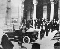 [Untitled]
 Heir to the Austro-Hungarian throne Archduke Franz Ferdinand and his wife, Sophie, get into a motor car to depart from the City Hall, Sarajevo, shortly before they were assassinated by the Serbian nationalist Gavrilo Princip on 28 June 1914.
-
 [Untitled]
 French trench mortar. (Dumezil) 58 mm.
-
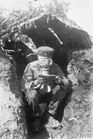 [Untitled]
 The First World War: German artilleryman wearing his gas mask whilst in a battery position near Les Boeufs on the Somme.
-
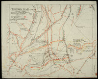 Trench Map from the Battle of the Somme
 This trench map was used by the Commander Royal Artillery (CRA) of 18th Division during the later stage of the Battle of the Somme. It is particularly interesting because it is ’embodying information from German prisoners’ and ‘corrected from air photographs taken on 3.10.16’. It shows how trench maps were frequently updated in the course of battle and how the use of photography was important for this. The map is hand drawn and annotated but only has a limited key in the top left. M.G. means machine gun, and the arrows on the symbols indicated their arcs of fire. German trenches are shown in red, while the hand-drawn coloured lines with numbers indicate the timings for the artillery barrage which would have supported an infantry assault – this would be directed on line ‘A’ between 0 and 2 minutes after Zero Hour, before lifting to line ‘B’ between 2 and 3 minutes from Zero, for example.
-
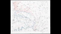
 A 16-mile Wide Area of Front Around the River Somme
 A 16-mile wide area of front around the River Somme, at the extreme right of the British held front line, was selected for a joint British and French attack in late June 1916. On 1 July the attack, following a week long bombardment and heralded by the exploding of underground mines, did not break through strong German defences.
Despite the lack of a ‘breakthrough’, this Ordnance Survey map of the area has been overprinted with the successive Allied territorial gains by the British 4th and reserve armies (coloured red) and the French 6th army (coloured blue) up to 31 July.
It emphasises the greater success towards the right and south of the line of attack, which the allies attempted to exploit in successive attacks throughout July. The approximate ‘dashed’ lines indicate the uncertainty and confusion of the front line at the time of printing.
-
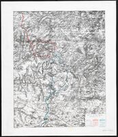
 Map of the Somme region
 Published in December 1916, this map of the Somme region marks the Allied advances there during the previous five months.
Overprinted blue lines give the successive front lines on the eve of the initial attack on 1 July, followed by 17 July, 13 September and 30 November.
Red indicates the complex German trench systems facing the attack. These are especially prevalent to the north of the front line, where the British attack was the least successful.
This map is unusual amongst military maps in that it was intended for public sale. Its production may well have been intended to emphasise the territorial gains (six miles in total) made during the offensive, and to justify the considerable human cost – over 400,000 British and dominion casualties – during what had become a controversial and highly criticised military operation.
-
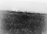 [Untitled]
 Battle of Albert. The 103rd (Tyneside Irish) Brigade, part of the 34th Division, advancing from the Tara-Usna Line to attack La Boisselle on the morning of 1 July. The 34th Division suffered heavier losses than any other division that day.
-
 [Untitled]
 The man on the left has been extricated from the mud into which he had sunk up to the arm pits. The soldier on the right is thought to be serving in the South Staffordshire Regiment, Beaumont Hamel, November 1916.
-
 [Untitled]
 Panorama of the ruins of Vaux and the valley of the Somme, 6 July 1916.
-
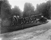 [Untitled]
 Guns captured in the Battles of the Somme, in the grounds of Querrieu Chateau, 4th Army H.Q.