Map of the Somme region
Item
-
Title
-
Map of the Somme region
-
Description
-
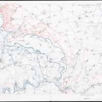
Published in December 1916, this map of the Somme region marks the Allied advances there during the previous five months.
Overprinted blue lines give the successive front lines on the eve of the initial attack on 1 July, followed by 17 July, 13 September and 30 November.
Red indicates the complex German trench systems facing the attack. These are especially prevalent to the north of the front line, where the British attack was the least successful.
This map is unusual amongst military maps in that it was intended for public sale. Its production may well have been intended to emphasise the territorial gains (six miles in total) made during the offensive, and to justify the considerable human cost – over 400,000 British and dominion casualties – during what had become a controversial and highly criticised military operation.
-
Date Published
-
December 1916
-
Subject
-
Western Front
-
Type
-
Map
-
Century
-
20th century
-
Decade material covers
-
1910s
-
Contemporary Country
-
France
-
Repository
-
British Library
-
Collection in Repository
-
World War One
-
Rights
-
With permission from the British Library
-
War
-
First World War
-
Battle
-
Battle of the Somme
-
Army
-
Great Britain