A 16-mile Wide Area of Front Around the River Somme
Item
-
Title
-
A 16-mile Wide Area of Front Around the River Somme
-
Description
-
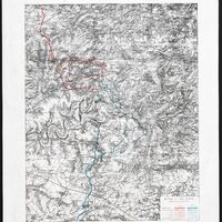
A 16-mile wide area of front around the River Somme, at the extreme right of the British held front line, was selected for a joint British and French attack in late June 1916. On 1 July the attack, following a week long bombardment and heralded by the exploding of underground mines, did not break through strong German defences.
Despite the lack of a ‘breakthrough’, this Ordnance Survey map of the area has been overprinted with the successive Allied territorial gains by the British 4th and reserve armies (coloured red) and the French 6th army (coloured blue) up to 31 July.
It emphasises the greater success towards the right and south of the line of attack, which the allies attempted to exploit in successive attacks throughout July. The approximate ‘dashed’ lines indicate the uncertainty and confusion of the front line at the time of printing.
-
Date
-
July 1916
-
Century
-
20th century
-
Decade material covers
-
1910s
-
Type
-
Map
-
Subject
-
Western Front
-
Contemporary Country
-
France
-
Repository
-
British Library
-
Collection in Repository
-
World War One
-
War
-
First World War
-
Army
-
Great Britain
-
Battle
-
Battle of the Somme
-
Rights
-
With permission from the British Library