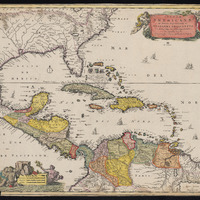
Insulae Americanae in oceano Septentrionali ac regiones adiacentes : a C. de May usque ad lineam aequinoctialem
Item
-
Description
-
Relief shown pictorially.
Shows southeastern North America as Florida with colony of Virginia, Pacific and Gulf coasts of Central America, northern coast of South America, and the West Indies.
Includes illustrations.
"For the French names on the Florida coast Visscher appears to have based his map on Mercator's Virginiae item et Floridae ... nova descriptio 1606. The plate appears to be the same used with the same title by Janssón, 1642; Guilielmus Blaeu, 1644; Johannis Blaeu, 1667; Valck and Schenk, 1710 (?")--cf. Philip Lee Phillips.
-
Date Created
-
1670
-
1690
-
Date Published
-
1670 to 1690
-
Subject
-
Caribbean Sea, North America, South America, Central America
-
Type
-
Map
-
Language
-
Latin
-
Format
-
Digital Facsimile
-
Short Title
-
Insulae Americanae in oceano Septentrionali ac regiones adiacentes
-
Source
-
From Visscher's Atlas minor.
-
Rights
-
These materials are in the public domain. No copyright permissions are needed. Acknowledgement of the Boston College University Libraries as a source for borrowed images is requested.
-
Public Domain
-
Spatial Coverage
-
Florida
-
Pacific
-
Gulf Coast
-
Central America
-
South America
-
West Indies
-
Caribbean
-
Mexico
-
Provenance
-
John J. Burns Library at Boston College
-
John J. Burns Library at Boston College
 Insulae_Americanae_17th