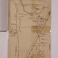
A Map of the Red Sea, From 24° to 30° North Lat., corrected from the Observations of late Voyages particularly those of the Author during a coasting Passage from Yambo to Cosibe
Item
-
Description
-
A hand-drawn map for publication. Includes Suez at the top and Yambo at the bottom. Emphasis on ports and coastal spaces with suggestion of hills and mountains.
Map designed to be folded.
-
Date Published
-
1780
-
Publisher
-
Printed for J. Dodsley
-
Place of Publication
-
London
-
Subject
-
Voyages and travels
-
Map
-
Personal account
-
Language
-
English
-
Century
-
19th century
-
Decade material covers
-
1890s
-
Contemporary Country
-
Saudi Arabia
-
Ethiopia
-
Repository
-
Burns Library
-
Collection in Repository
-
Williams
-
Region
-
Mediterranean
-
Arabia
-
East Africa
-
pages
-
69

 00000096.jpg