A New and Correct Map of the Coast of Africa: From Sta. Cruz Lat. 30 North to the Coast of Angola Lat. 11 S: With Explanatory Notes of All the Forts and Settlements Belonging to the Several European Powers
Item
-
Date Published
-
1764
-
Contributor
-
bookseller John Bowles
-
bookseller Carington Bowles
-
former owner Joseph J Williams (Joseph John)
-
Publisher
-
London
-
Printed for John Bowles in Cornhil, and Carington Bowles in St. Pauls Church Yard
-
Subject
-
18th century
-
Africa
-
Angola
-
Colonies
-
Early works to 1800
-
Forts
-
Maps
-
Gold Coast
-
Type
-
Map
-
Language
-
English
-
Short Title
-
A New and Correct Map of the Coast of Africa
-
Temporal Coverage
-
18th century
-
Abstract
-
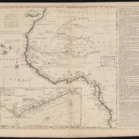
Relief show pictorially., Horizontal bar scale given in English leagues "of which 239 L make a degree at the equator" with equivalents in Portuguese leagues and Dutch miles., At right "Explanation of the coast of Africa &c"; with numbered references 1-34., Inset: A Correct chart of the Gold Coast according to Sr. Danville on a larger scale., Carington Bowles traded at St. Paul's Churchyard from 1764., A reissue of this map, with imprint dated 1771, appears in Carington Bowles's General atlas of thirty-six new and correct maps (1771).
-
lccn
-
G8735 1764 .N49 FLAT STORAGE
-
Provenance
-
John J. Burns Library at Boston College