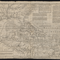
An Accurate Map of the West Indies: Exhibiting Not Only All the Islands Possess'd by the English, French, Spaniards & Dutch, but Also All the Towns and Settlements on the Continent of America Adjacent Thereto
Item
-
Description
-
Relief shown pictorially.
West Indies map with southern United States, Central America and northern South America showing landforms, drainage, cities, prevailing winds, historical notes, explanatory text, and other landmarks.
Title in box at top middle., "Emanl. Bowen, sculpt."
Scale statement adjacent to right latitude lines.
Prime meridian: London.
Geographic coordinates converted to Greenwich.,
Originally published in Cave's first edition geography text.
Below imprint is text advertising Cave's publication, Geography reformed; or a new system of general geography., Detached from: Gentleman's Magazine, vol. 10.
Map listed in contents page for Jan. 1740 edition. One of the historical notes refers to Gentleman's Magazine for reference.
-
Date Published
-
1740
-
Contributor
-
Edward Cave (publisher)
-
Joseph J. Williams (former owner)
-
Publisher
-
London
-
Printed for E. Cave at St. Johns Gate
-
Subject
-
18th century
-
Caribbean Area
-
Early works to 1800
-
Maps
-
Southern States
-
West Indies
-
Language
-
eng
-
Short Title
-
An Accurate Map of the West Indies
-
Rights
-
Public Domain
-
lccn
-
G4390 1740 .B69 FLAT STORAGE
-
Provenance
-
John J. Burns Library at Boston College