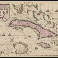
A New Chart of the Seas Surrounding the Island of Cuba with the Soundings, Currents, Ships, Courses &c. and a Map of the Island Itself Lately Made by an Officer in the Navy
Item
-
Description
-
Relief shown pictorially.
Depths shown by soundings.
In upper margin: For the London magazine 1762., Includes indexed inset of "A plan of the harbour & town of Havana" and ill.
-
Date Created
-
1762
-
Date Published
-
October 1762
-
Publisher
-
London
-
Printed for R. Baldwin
-
Subject
-
18th century
-
Cuba
-
Early works to 1800
-
Maps
-
Type
-
Map
-
Language
-
English
-
Format
-
Digital facsimile
-
Short Title
-
A New Chart of the Seas Surrounding the Island of Cuba with the Soundings
-
Source
-
From The London magazine, or, Gentleman's monthly intelligencer. Oct. 1762, v. 21.
-
Rights
-
These materials are in the public domain. No copyright permissions are needed. Acknowledgement of the Boston College University Libraries as a source for borrowed images is requested.
-
Public Domain
-
lccn
-
99138061301701021
-
Provenance
-
John J. Burns Library at Boston College
-
John J. Burns Library at Boston College

