World Travel and Description project is a collaborative data and mapping project, which allows users to read and look at different place descriptions over hundreds of years. Through those different people’s descriptions, users can get a sense of how the different places changed over time. Furthermore, by allowing users to look at descriptions of people down occupational, place of origin, sees participants take historic travel accounts in the public domain and turn them into structured data.
Genre of text: Travel narratives
Course level: beginner
Student difficulty: low to moderate
Teacher Preparation: low to medium
Semester time: mid- or late-semester
Estimated time: forty minutes prior to class, fifty minutes in class
Learning Objectives:
Recommend the instruction pick a three of the following to emphasize:
- To understand what semi-structured and structured data are and how to transform one data type into another
- To learn how to create a clean dataset in a collaborative project setting
- To learn about spatial data (latitude and longitude)
- Begin learning about different tools for data organization and manipulation including
- Consider how data is subjective by think about authorial bias in seemingly objective place description
- Think about how humans interacted with and experienced space and specific places
Exercise:
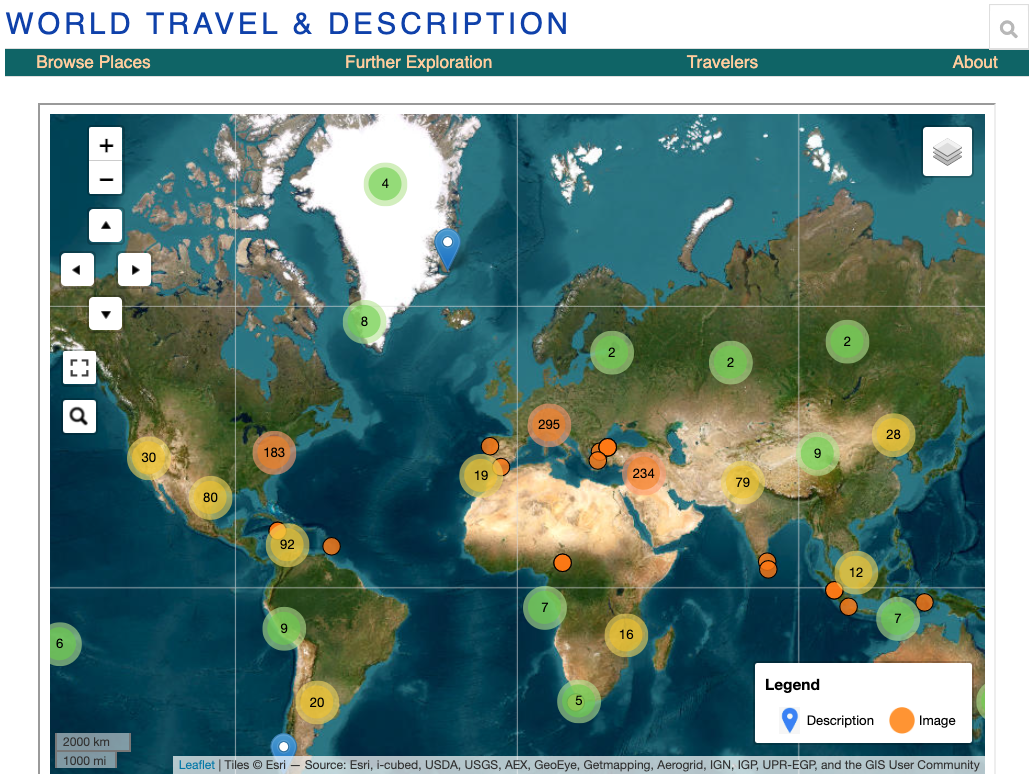
What is the World Travel & Description Project?
- Introduce the World Travel & Description project (https://dhprojects.bc.edu/s/travelanddescription/) - note to students that this is a growing project site that’s recently started. The goal is to have thousands of points, allowing students to explore people’s descriptions to see historical change over time
- Navigate to a traveler page
- Click Further Exploration in the toolbar (https://dhprojects.bc.edu/s/travelanddescription/page/geographic)
- Look at the “Travelers” list and note that there are only a few → but the A projects will get to add to the list
- Show them “Thomas Gage” (https://dhprojects.bc.edu/s/travelanddescription/page/thomasgage)
- Tell the students that this class project draws on a 19th century text as well as open access (not under copyright) images to create a story about how this individual traveled
- Talk to the students about how the project fits into your specific class
How to do the travel and description project
- Tell students that what they’ll be doing is pulling a book about someone’s travels in which they describe different places around the world.
- Take the students to all or one of the following (recommend showing the first and fourth)
- Project Gutenberg
- Internet Archive
- HathiTrust
- Your library’s catalog (BC Catalog)
- Show students how to look for material relevant to your class (or provide them with a list)
- Suggested search for HathiTrust or library catalog in different search fields of the advanced search:
- (travel OR description OR voyage)
- ([continent] OR [country] OR [city] OR [place])
- ([century] OR [event] OR [decade] OR [year])
- Suggested search for HathiTrust or library catalog in different search fields of the advanced search:
- Tell the students that there are three main kinds of data: structured (tables); semistructured (like books); and unstructured (like a pile of notes on your desk).
- To work with a project involving mapping, charts, or other kinds of visualizations, one has to work with structured, clean data. For this project, that means turning
- a book–semi-structured data–into a chart, which is structured data.
- Show the students a screen shot of the Travel and Description Dataset
The Task
Take the chosen travel book and assign each student one or two passages (recommended letters) to add to teh